|
включая
ответ
|
Location
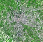
Satellite image of Rome, showing natural and built
environment in the city
Rome is in the Lazio region of
central Italy, at the confluence of the Aniene and Tiber (Italian:
Tevere) rivers. Although the city center is about 24 kilometers
inland from the Tyrrhenian Sea, the city territory extends to the
very shore, where the south-western Ostia district is located. The
altitude of Rome ranges from 13 meters above sea level (in Piazza
del Popolo) to 120 meters above sea level (the peak of Monte
Mario).[citation needed] The comune of Rome covers an overall area
of about 1,285 square kilometers, including many green
areas.
Climate
Rome
enjoys a typical Mediterranean climate which characterizes the
Mediterranean coasts of Italy. It is at its most comfortable from
April through June, and from mid-September to October; in
particular, the Roman ottobrate (ottobrata can roughly be
translated as "beautiful October day") are famously
known as sunny and warm days. By August, the temperature during
the heat of the day often exceeds 32° C (90° F);
traditionally, many businesses would close during August, and
Romans would abandon the city for holiday resorts, but this trend
is weakening, and the city is increasingly remaining fully
functional during the whole summer, in response to growing
tourism as well as change in the population's work habits. The
average high temperature in December is about 14° C (57°
F).
|
